|
|


Subic Bay Freeport
A strategic and competitive gateway to your market
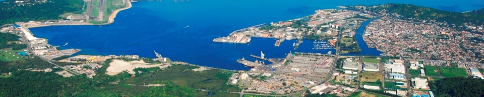
Subic Bay Freeport Zone (SBFZ) is the first free port of the Philippines and one of the world's successful models of military base conversion into socio-economic purposes.
Carved from the former United States Naval Base, once the largest U.S. military naval base in Asia and home to the US Seventh Fleet, SBFZ is 68.35 miles (110 kilometers) from Manila and covers 262 square miles (670 square kilometers).
It is located in the Central Luzon region and straddles portions of the city of Olongapo and the town of Subic in the province of Zambales, as well as the towns of Hermosa and Morong in the province of Bataan.
Subic Bay opens to the South China Sea while the western part of its harbor faces the Zambales mountain range, making it naturally sheltered from typhoons.
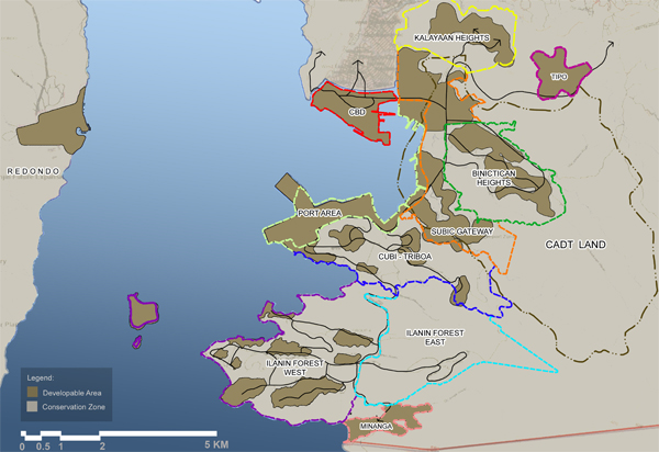
Binictican Heights [642.55 hectares]
A mix of single detached residences, duplexes and row houses with a small neighborhood-level convenience type commercial area, as well as a golf course, a retirement village, an international school, parks, playgrounds and other recreational/sports facilities with a preservation zone surrounding the district to contain and provide an edge to the development.
Certificate of Ancestral Domain Title (CADT) Land [4,555.93 hectares]
A large area of existing developments, as well as open grassland and Aeta settlements, which also accommodates mixed land uses including conservation and preservation zones
Central Business District (CBD) [182 hectares]
A predominantly commercial area with a mix of institutional, recreational, light industrial, medium- and high-density residential areas, and other compatible land uses as well as a large number of retail shops and restaurants.
Cubi-Triboa District [720.50 hectares]
A mixed land use zone, consisting of residential, commercial and recreational areas, as well as a special institutional land use, and which also incorporates preservation zones.
Ilanin Forest East [919.45 hectares]
A conservation zone, which is predominantly forest in character and where limited low-intensity recreational land use may be allowed but subject to strict environmental controls, such as no cutting of trees and conservation of natural drainage channels
Ilanin Forest West [1,223.57 hectares]
A conservation zone, which can accommodate medium-intensity recreational and commercial land uses in its developable portions, subject to strict environmental controls, including the retention of its forest character.
Kalayaan Heights [452.66 hectares]
A low-density residential area of duplexes and single detached residences with schools, parks, playgrounds and other recreational/sports facilities, and developable areas surrounded by a preservation zone to contain and provide an edge to the development.
Port District [324.53 hectares]
An area principally used for shipping port, container yards, and heavy equipment and vehicle yards with warehouses, silos, and other storage facilities for dry goods; as well as tank farms and petroleum oil storage facilities, including pipelines, loading facilities, piers, pumps and other equipment and facilities supportive of such operations
Redondo Peninsula [3,596.81 hectares]
Predominantly industrial in the developable areas of this District with a mix of residential, commercial and institutional land uses to make it an industrial town with its non-developable areas as a preservation zone
Subic Bay Forest District [4,814.62 hectares]
Tipo Area
An area of mixed uses, including commercial/business offices and light industrial zones are separated by an open space/natural drainage easement from the residential zone
-
Minanga Area
A conservation zone with low- to medium-intensity recreational and residential land uses with the area fronting Minanga Bay reserved for mixed medium-intensity recreational and residential use, and the upland and forested portion for low-intensity residential use but with a conservation zone to retain its existing forest character and subject to strict environmental controls.
Subic Gateway [723.69 hectares]
A large land area, which has been broken up into two (2) sub-districts and separated by a preservation zone, for different land uses - ranging from predominantly industrial to a mix of commercial and industrial land uses.

External Links
E-Billing & Payment System | Official Gazette of PH | BCDA | Clark | Clark is it | Subic Bay Freeport Chamber of Commerce | DMIA | Subic Bay HATS Visitors Board | FIRBSubic Bay Metropolitan Authority. All Rights Reserved. Bldg. 229 Waterfront Road, Subic Bay Freeport Zone, Philippines.
Voice: +6347 252 7262 Fax: +6347 252 5278 | Terms of Use | Sitemap
ISO Certified - DQS |

Transparency Seal |

Freedom of Information |
|